

This place rocks.
Nevada is part of what geologists call the Basin and Range Province, which extends from northern Mexico to southern Oregon and Idaho. Dominated by long, arid valleys separated by north-south mountain ranges, this rugged area is formed by uplifted and downfallen blocks of the Earth’s crust with faults lying along both sides of the valleys.
With 314 mountain ranges, Nevada is the most mountainous state in the United States. Five of these ranges are to be found in Black Rock-High Rock Country; many others are within sight.
Movement of the earth’s tectonic plates causes broad regional uplift, depression, and/or volcanic activity. In the Black Rock High Rock National Conservation Area (NCA), volcanic activity has moved slowly from east to west. Later, broad regional stretching of the earth’s crust caused the series of fault blocks and valleys found in the NCA and Great Basin.
Erosion by wind and water cuts through rock and soil and deposits this eroded material elsewhere. The Black Rock Playa and alluvial deposits are made of material eroded from surrounding mountain ranges. High Rock Canyon was cut by water erosion that was channeled by a large fault.
Gravity moves material downhill and deposits it. Landslides can cause sudden, dramatic changes to the landscape. High Rock Lake was created when a landslide blocked the out flow of water.
Igneous processes can cover the land surface with erupted material, or blast whole mountains away when a caldera explodes. Many of the rocks in the NCA are of volcanic origin.
Glaciers move and deposit material and can depress the land by their weight. Blue Lake is a cirque lake caused by an old glacier in the Pine Forest Range just outside the NCA boundaries.
Ancient Geologic History
Before dinosaurs roamed the earth, during a time called the Paleozoic Era, much of what is now western North America was not attached to the continent at all. California, Oregon, Washington, and parts of Idaho and Nevada had not formed yet. The coastline ran east of Nevada, splitting it along a northeast-running line. What is now the NCA was located over the equator.
To the west of this ancient coastline was a subduction zone, a trench where one plate slowly moves under another. In this case, the denser Oceanic Plate melted as it was subducted beneath the North American Plate, resulting in a series of volcanic island chains.
A piece of the Oceanic Plate with a series of volcanic island chains eventually collided with and accreted to the western edge of the North American Plate. This newly attached land contained volcanic rocks inter-laced with oceanic sediments, such as the black limestone of the Black Rock. These rocks now make up or underlie much of northwestern Nevada, including the Black Rock, Pine Forest, and Jackson Ranges. The Black Rock itself, the namesake of the desert, is a piece of an ancient island chain.
From far away its black color fools the eye. It looks like basalt, but the Black Rock is really made up of fi ngers of volcanic rocks and limestone, remnants of those transported island chains.
Look closely. You may find marine fossils in the rock!
Mountain Ranges
Nevada has over 300 named mountain ranges, several of which are within the NCA. Why are there so many ranges? The answer has to do with the stresses on the crust across the entire area between the Sierra Nevada and the Wasatch Range in Utah. This whole area is being stretched thin from east to west.
This stretching broke the crust into fault blocks which tilted and slipped to form a series of basins and ranges. Sediments eroded from the top of the ranges have fi lled the basins below. The NCA is part of this Basin and Range region.
These faults have been conduits for relatively recent volcanic activity within the NCA. In addition, hot mantle rocks close to the surface heat groundwater which gives the region its many hot springs.
Volcanic Activity
A series of volcanic rocks, lavas, ash flows, and breccias blanket the northwest portion of the National Conservation Area. These rocks, dated from roughly 30 to 15 million years ago, also cover parts of the Calico and Black Rock ranges.
The High Rock area contains the remnants of several extinct volcanic calderas. The Soldier Meadows basin is a caldera, formed by an explosion and resulting collapse of a large volcano.
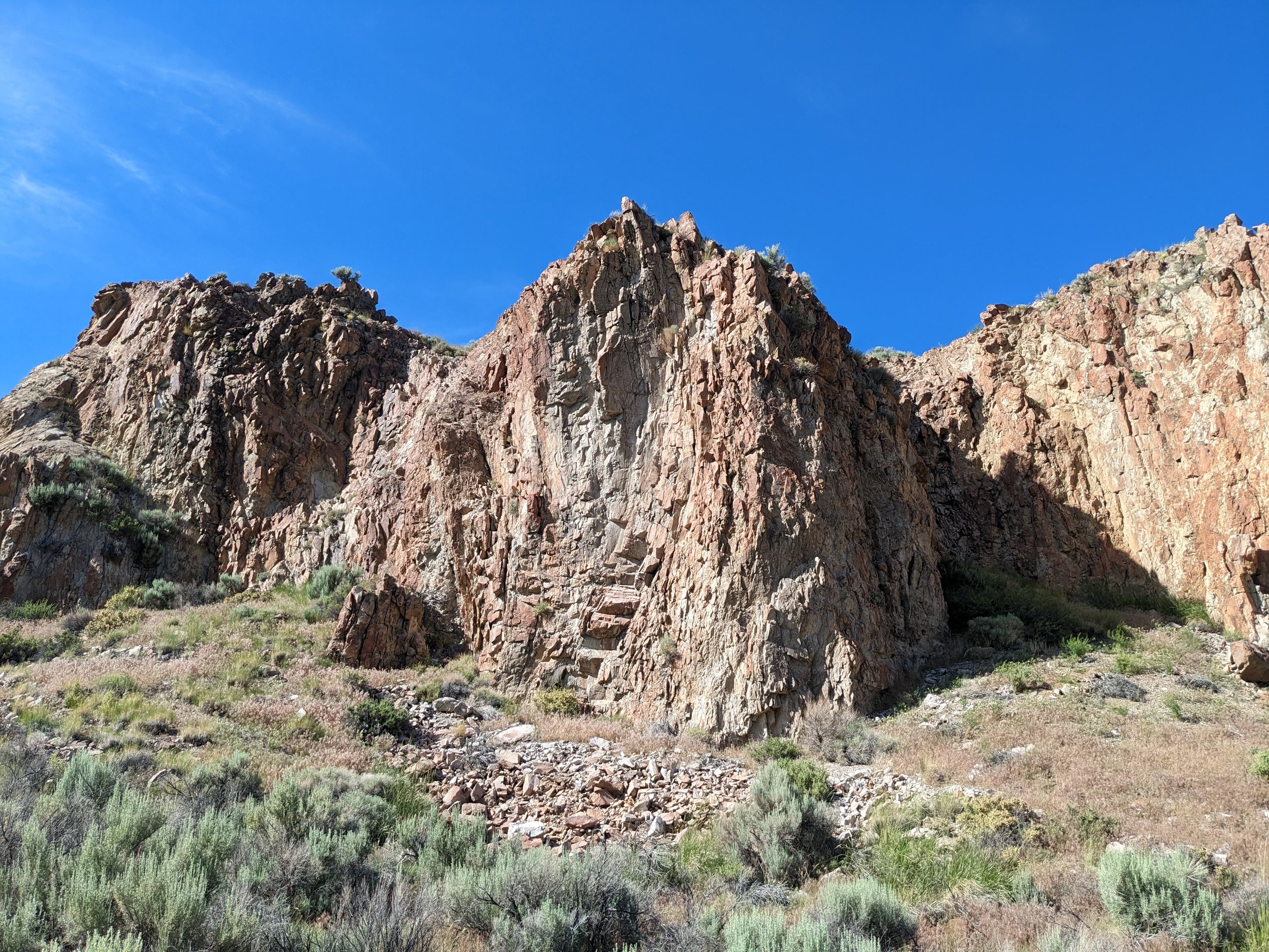
The rocks themselves vary in composition from basalt to rhyolite, which is the volcanic equivalent of granite and is found in High Rock Canyon. Rhyolite eruptions tend to be explosive and violent with more ash than lava.
Take a close look at the rocks that make up the canyon walls to see fl ow banding. Many people think this is the result of tectonic forces, but it is actually the result of fl ows from the volcanic eruption that produced the rock.
Volcanic rocks commonly bear mineral deposits when altered by hot water. Prospectors have always had hope for this region but economically valuable deposits are comparatively sparse within the NCA.
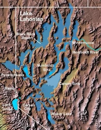
Ancient Lake Lahontan
Can you see horizontal terraces on the lower slopes of the mountains surrounding the playa? These are old shorelines of Lake Lahontan that once fi lled the Black Rock Desert and most of the basins of northwest Nevada.
This huge lake was deepest during the last Ice Age around 14,000 years ago. The highest shoreline is 514 feet above the current playa surface. With no outlet, Lake Lahontan slowly dried up when the climate no longer provided it with enough water to maintain the lake.
The Playa
Today, the white playa silt hides the ancient gravel surface of the Lahontan lake bed. The playa surface covers over 100,000 acres and the playa sediments are over 10,000 feet deep at the thickest point.
The intermittent Quinn River floods the East Arm of the playa seasonally with a small amount of water and fi ne sediments.
In the dry season, the water simply evaporates into the atmosphere again. The evaporation leaves behind dissolved mineral salts, making the playa surface unsuitable for most plants.
As the playa dries, cracks form on the surface because the playa is composed of fine silt and clay minerals. When they are waterlogged, clay minerals expand, and when they dry out, they contract to form the familiar cracked pattern seen on the lake bed.
Lake Lahontan deposited these fine sediments slowly and evenly on the floor of the lake, creating the extremely fl at surface that you see today. The coarser eroded materials were deposited quickly in the alluvial fans close to the mountains from which they eroded.
Fossils
A number of interesting fossils have been found in the Black Rock Desert.
At least two mammoths met their end bogged down in Lake Lahontan’s muddy shore. Their fossilized skeletons have been excavated and can be viewed at the Humboldt County Museum and the Nevada State Museum.
In the northern portion of the NCA, layers of volcanic ash contain plant and animal fossils. These include ancient pigs and horses from between 13 and 15 million years ago.
Petrified wood is a common fossil in the area. One example is located just outside the The Lund Petrified Forest boundary of the NCA on Highway 34. A forest of Giant Sequoias grew here 16 million years ago when the climate of the region was very different.
A volcanic eruption smothered whole groves of these trees with volcanic ash. The ash preserved them and water-deposited silica replaced the wood so entire stumps and logs remain intact as fossils today.
Hot Springs
Hot Creek in Soldier Meadows
Because the earth’s hot mantle rocks are relatively close to the surface in the Great Basin, springs with geothermally heated water are common throughout the region.
Some hot springs in the NCA are particularly interesting because they provide habitat for species that are found nowhere else on earth. These vestiges of Pleistocene lifeforms have been isolated long enough after the evaporation of Pleistocene lakes to have evolved into distinct species that are found only in those springs.
While soaking in these springs can be enjoyable, we ask you to be careful. Some springs are hot enough to scald and very dangerous. Habitat for rare species can be ruined by pool-building, sunscreen, and soap contamination. Please respect these unique resources.
Geologic Points of Interest
Black Rock Point
This major landmark for the Applegate-Lassen Trail is made of andesitic lavas and fossil-bearing limestone, a result of the collision of the Oceanic Plate with the North American Continental Plate.
Volcanic material from ancient island chains is interlaced with deposits from the ancient sea that surrounded them. You might find marine fossils in the blackened limestone!
High Rock Canyon
The walls of High Rock Canyon west of Soldier Meadows are made of layers of thick rhyolite, welded tuff, and lava flows. The deeply incised canyon was eroded by water that was concentrated and channeled along a structural weakness (fault) in these volcanic layers.
Fly Canyon & High Rock Lake
Erosion produces dramatic landforms in the desert. The landscape looks like it is unchanging, with most erosion and deposition happening too slowly to see, but sometimes, catastrophic events shape the land suddenly.
One of the NCA’s most dramatic erosional features is near High Rock Lake. Long ago, a massive landslide in Box Canyon blocked the flow of water to create a natural dam. High Rock Lake formed behind the landslide dam until the water rose to the level of another outlet, Fly Canyon.
Sudden out flows of water from High Rock Lake tore away the rock of Fly Canyon. Violent vortices of water and rock drilled holes in the streambed. Emigrants passing through this canyon noted huge potholes in the stream bottom with one almost one hundred feet wide and undercut twenty feet at the bottom.
Haystack Butte
This distinctive landmark is a 115-million-year-old chunk of Cretaceous granite that is surrounded by an apron of recent Pleistocene lake deposits. It sits above the surrounding lake deposits because the granite is more resistant to erosion than the softer lake deposits. The butte was a prominent landmark for the emigrants heading and is located north of Rye Patch Reservoir, outside the NCA.